Showing 49 items matching point clear
-
 Mt Dandenong & District Historical Society Inc.
Photograph, View from Point Clear, Mt Dandenong, Vic
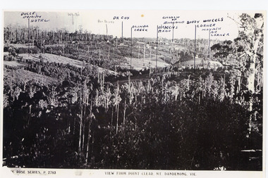
... View from Point Clear, Mt Dandenong, Vic...Point Clear...Copy of Rose Series postcard #2783 showing view from Point...-and-the-dandenong-ranges Photograph View from Point Clear, Mt Dandenong, Vic ...Rose Series Postcard number 2783Copy of Rose Series postcard #2783 showing view from Point Clear. This is taken from Ridge Road. The following indicators have been marked on the photograph L-R Dulce Domun Hotel, White's, Rev. Davies, Dr. Cox, Olinda Creek, Dickens Road, Church of England, Buggy Wheels Corner, Monash Ave. Corner.mount dandenong, ridge road, rose series, point clear -
 Mt Dandenong & District Historical Society Inc.
Photograph
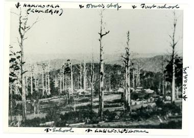
... point clear... in 1913 from an area known as Point Clear that shows the buildings... an area known as Point Clear that shows the buildings of early Mt ...Iconic photograph taken by Edgar Dower on Ridge Road in 1913 from an area known as Point Clear that shows the buildings of early Mt Dandenong before the CRB road went through in the 1920s.Black and white photograph with tall, dead trees in foreground and a view of hills in the distance. Buildings can be seen across the centre of the photograph. There are handwritten annotations around the border with arrows referring to areas in the photograph. Reverse of photograph has handwritten description by John Lundy-Clarke.Front from top left: Namoora (Lumeah), Dower's Shop, First school, Talent's, Langford's house, School. Reverse: 1913 view from O'Halloran's LOT 4, Section 3 on Ridge Road. Showing Lumeah (Namoora) Farndons Road (fence) School, Lowes House?, Falls Road Shop (Dowers) Langford's Falls Road (LOT 9, Section 1) Shed on Colomb's LOT 19, Sect 2 Colomb's House (Fergusons) First school Campbell's Blythes Road Lil Badenhop's P.O. In middle distance - Talent's homestead and sheds.point clear, namoora, lumeah, langford, dower, talent, colomb, ferguson, campbell, farndons road, mt dandenong school -
 Mt Dandenong & District Historical Society Inc.
Photograph
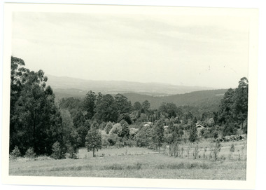
... Point Clear... on Ridge Road that became known as Point Clear showing the Mt... Point Clear Mt dandenong John Lundy-Clarke Peter Damman ...In 1913 Edgar Dower took a photograph from this spot on Ridge Road that became known as Point Clear showing the Mt Dandenong township behind a stand of tall, dead trees. John Lundy-Clarke took this photograph from a similar spot at the Mt Dandenong Arboretum in 1975.Black and white photograph showing a cleared area in the foreground with young tress in the centre and hills in the distance. Several rooftops can be seen mid photo on the right. Reverse of photograph has handwritten description by John Lundy-Clarke.1975 View from the Arboretum over Mt D'nong township at the spot where Edgar Dower took the 1913 photo. The Falls gully is in the middle distance. Peter Damman's fence running downhill right foreground.edgar dower, point clear, mt dandenong, john lundy-clarke, peter damman, arboretum -
 Tennis Australia
Ball container, Ball, Circa 1975
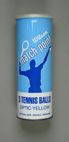
... A sealed can of three Wilson 'Optic Yellow Match Point... of three Wilson 'Optic Yellow Match Point' tennis balls. Clear ...A sealed can of three Wilson 'Optic Yellow Match Point' tennis balls. Clear plastic reclosure cap over a ring-pull style lid. Materials: Metal, Ink, Rubber, Synthetic materialtennis -
 Federation University Historical Collection
Letter - Document, Correspondence to the Ballarat School of Mines, 1899-1901
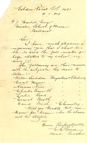
... , Mount Clear, Golden Point, Humffray Street, Macarthur Street..., Mount Clear, Golden Point, Humffray Street, Macarthur Street ...The Ballarat School of Mines held specialist classes for State School Students, including Chemistry and Electricity & Magnetism. Thirty three letters to the Ballarat School of Mines between 1899 and 1904. Some of the correspondence relates to Electricity, Chemistry, Physics and Mineralogy classes for State School students run by the Ballarat School of Mines. The Schools involved were Urquhart Street, Brown Hill, Queen Street, Dana Street, Eureka Street, Mount Pleasant, Sebastopol, Little Bendigo, Mount Clear, Golden Point, Humffray Street, Macarthur Street, Pleasant Street, and Wendouree. .2) Handwritten on lined foolscap paper: 'Golden Point S.S. 1493 10.8.04 F.J. Martell Esq Director, School of Mines, Ballarat Sir, I have much pleasure in informing you that I shall be able to send the full number of boys allotted to my school, viz., seven (7). The following are their names with the subject they desire to take: Walter Sneddon Magnetism & Electricity Cecil Major Magnetism & Electricity Norman Nice Magnetism & Electricity Charles Tinsworth Magnetism & Electricity Leslie Reed Magnetism & Electricity Ernest Booth Magnetism & Electricity David Both Magnetism & Electricity David Birch Chemistry Will you kindly let me know per bearer when the classes will be started. I am Yours respectfully, E.C. Perrin, Head Teacher.' ********* .8) Handwritten on lined paper 'State School 1071 Eureka St, Ballarat East 13/8/04 Sir, In reply to your letter of 8th Inst. I wish to infrom tou that seven boys from teh above school will attend the science classes at teh School of Mines and all of them desire to rak Chemsitry and mineralogy. Yours respectfully R.J. Burke Fred. J Martell Esq.' ********* .22) Eureka St S.S. Ballarat East 23 Aug 1904 Dear Sir, In reply to your last letter I wish to state that Friday afternoon will suit my school the better (for boys attending science lectures) Yours faithfully R.J. Burke F.J. Martell.' ********* .26) Handwritten on lined foolscap paper 'State School 1493 Golden Point 1.9.04 F.J. Martell Esqr. Director School of Mines Sir, The following are the names and classes of the boys from the above school: Charles Tinworth Electricity Ernest Book Electricity Neil Petch Electricity Cecil Major Mineralogy Norman Nice Physics Walter Sneddon Physics David Baird Chemistry Yours faithfully E.C. Perrin, Head Teacher education, school, state school, golden point state school, golden point primary school, eureka street state school, eureka street primary school, perrin, frederick martell, dana street primary school, sebastopol primary school, pleasant street state school, sebastopol state school, mount pleasant state school, mt pleasant state school, mount pleasant, sebsatopol, golden point, charles tinworth, chemistry, electricity, physics, mineralogy, cecil major, norman nice, david baird, walter sneddon, e.c. perrin, leslie reed, ernest booth, david birch, david booth, dana street state school -
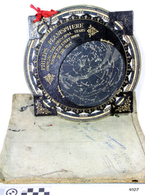 Flagstaff Hill Maritime Museum and Village
Planisphere, Early 20th Century
The word Planisphere (Latin planisphaerium) was originally used in the second century by Claudius Ptolemy to describe the representation of a spherical Earth by a map drawn in the plane. This usage continued into the Renaissance: for example Gerardus Mercator described his 1569 world map as a Planisphere. The word describes the representation of the star-filled celestial sphere on the plane. The first star chart to have the name "Planisphere" was made in 1624 by Jacob Bartsch. Bartsch was the son-in-law of Johannes Kepler, discoverer of Kepler's laws of planetary motion. A significant item of celestial mapping used by marine navigators This particular item was made and used in the first quarter to half of the 20th centuryPlanisphere of northern hemisphere, with canvas bag. Planisphere consists of a circular star chart attached at its centre to an opaque circular overlay that has a clear elliptical window or hole so that only a portion of the sky map will be visible in the window or hole area at any given time. The chart and overlay are mounted so that they are free to rotate about a common pivot point at their centres. The star chart contains the brightest stars, constellations and (possibly) deep-sky objects visible from a particular latitude on Earth. The night sky that one sees from the Earth depends on whether the observer is in the northern or southern hemispheres and the latitude. A Planisphere window is designed for a particular latitude and will be accurate enough for a certain band either side of that. Planisphere makers will usually offer them in a number of versions for different latitudes. Planispheres only show the stars visible from the observer's latitude; stars below the horizon are not included. A complete twenty-four-hour time cycle is marked on the rim of the overlay. A full twelve months of calendar dates are marked on the rim of the starchart. The window is marked to show the direction of the eastern and western horizons. The disk and overlay are adjusted so that the observer's local time of day on the overlay corresponds to that day's date on the star chart disc. The portion of the star chart visible in the window then represents (with a distortion because it is a flat surface representing a spherical volume) the distribution of stars in the sky at that moment for the Planispheres designed location. Users hold the Planisphere above their head with the eastern and western horizons correctly aligned to match the chart to actual star positions. "Made in Germany for GEORGE PHILIP & SONS Ltd. Geographical and Educational Depot, 32 Fleet Street, London" Canvas bag has "Capt. H (Howard) Tyler from Captain H. F. Woolf" "Tyler 22 ? St East Brighton" also "13 Halls St Flinders"flagstaff hill, warrnambool, shipwrecked-coast, flagstaff-hill, flagstaff-hill-maritime-museum, maritime-museum, shipwreck-coast, flagstaff-hill-maritime-village, planisphere, star map, marine navigation, maps, george philip & sons -
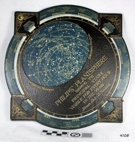 Flagstaff Hill Maritime Museum and Village
Planisphere, Early 20th Century
The word Planisphere (Latin planisphaerium) was originally used in the second century by Claudius Ptolemy to describe the representation of a spherical Earth by a map drawn in the plane. This usage continued into the Renaissance: for example Gerardus Mercator described his 1569 world map as a Planisphere. The word describes the representation of the star-filled celestial sphere on the plane. The first star chart to have the name "Planisphere" was made in 1624 by Jacob Bartsch. Bartsch was the son-in-law of Johannes Kepler, discoverer of Kepler's laws of planetary motionA significant item of celestial mapping used by marine navigators This particular item was made and used in the first quarter to half of the 20th century.Planisphere consists of a circular star chart attached at its centre to an opaque circular overlay that has a clear elliptical window or hole so that only a portion of the sky map will be visible in the window or hole area at any given time. The chart and overlay are mounted so that they are free to rotate about a common pivot point at their centers. The star chart contains the brightest stars, constellations and (possibly) deep-sky objects visible from a particular latitude on Earth. The night sky that one sees from the Earth depends on whether the observer is in the northern or southern hemispheres and the latitude. A Planisphere window is designed for a particular latitude and will be accurate enough for a certain band either side of that. Planisphere makers will usually offer them in a number of versions for different latitudes. Planispheres only show the stars visible from the observer's latitude; stars below the horizon are not included. A complete twenty-four-hour time cycle is marked on the rim of the overlay. A full twelve months of calendar dates are marked on the rim of the star chart. The window is marked to show the direction of the eastern and western horizons. The disk and overlay are adjusted so that the observer's local time of day on the overlay corresponds to that day's date on the star chart disc. The portion of the star chart visible in the window then represents (with a distortion because it is a flat surface representing a spherical volume) the distribution of stars in the sky at that moment for the Planispheres designed location. Users hold the Planisphere above their head with the eastern and western horizons correctly aligned to match the chart to actual star positions. "Sold by J DONNE & SON, Booksellers & Stationers, 349 Post Office Place Melbourne 349. Admiralty Chart Agents" and " Made in Germany for George Philip & Son Ltd" England . Signature "Capt E. B. ?..id, 22 Baund St"flagstaff hill, warrnambool, shipwrecked-coast, flagstaff-hill, flagstaff-hill-maritime-museum, maritime-museum, shipwreck-coast, flagstaff-hill-maritime-village, star map, marine navigation, maps, george philip & sons -
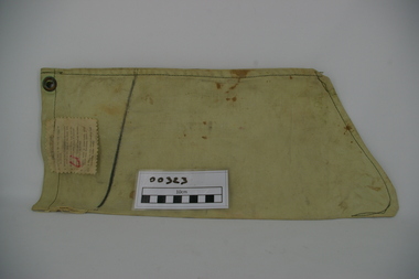 Frankston RSL Sub Branch
Bag, Water Filter
Single person water filter bag used by World War 2 service personnel to obtain clear water when in the field. This filter type is known as a "Millbank Filter". The filter is in the form of a light green canvas bag shaped like a sock and is designed to collect and filter particles and parasites from groundwater, etc. The canvas is of a fine weave which allows the water to filter slowly from inside the bag. The top of the filter bag has brass eyelets set on opposite sides for hanging from a tree or other point during water filtering. On one side of the bag has been stamped in permanent black ink 'CAT No A.F.0005' and 'M&Co.(N) BROAD ARROW 1945'. A cotton label has been sewn near the bag top with a printed six step instruction list for use of the filter bag. Below this is a line marked in permanent black marker to let the user know when to start collecting the water draining from the bag.The bag is imprinted with the following: 'CAT No A.F.005' and has a square box imprint with 'M&Co.(N) ^ 1945'. -
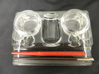 Kiewa Valley Historical Society
Ink Well - Mt Beauty Post Office
This inkwell was used by the staff of the Mount Beauty Post Office, from the late 1940's until the change from pen and ink to the use of fountain pens and then ball-point pens. The last Post Master at Mount Beauty rescued this item when the Mt Beauty Post Office was privatised in the 1990's. Ian Mc Kendrick worked at the Mt Beauty post office.Clear glass rectangular shaped set of two ink wells with a pen holder in front. Each ink well has a glass lid. Between the ink wells there is an open area for storing items such as paper clips etc. In addition it Includes a red and a black pen handle.mt beauty post office. inkwell. pen. writing equipment. -
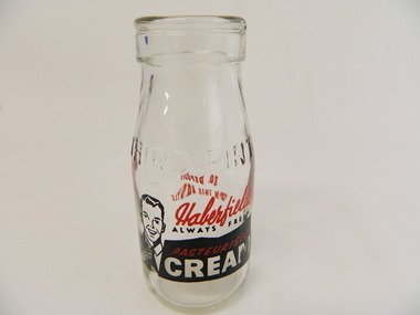 Kiewa Valley Historical Society
Bottle - Cream, Pre 1966
Cream was stored and sold in bottles and bought at a local store. History of Haberfield's. The measurement of liquids was in pints and money in pence (d) pre 1966. Bottles were returned to the manufacturer who reused the bottle. To encourage the return of bottles, collectors were given 3d (pence) per bottle. Historical: Dairy farmers living in the Kiewa Valley, sent their milk to be separated into cream by a Dairy company and then sold to the public. Aesthetic: Display showing variations of shape, embossing and stencillingSmall clear glass bottle containing one third of a pint and used to carry cream. it tapers to a lip at the neck. On one side and the base it is heavily embossed. Under the embossing on the side it is stencilled in red and black words and outline of a picture of a happy man wearing a tie pointing to the writing.Base: Common Seal with 'A' and 'G' and 'M' inside the 'A'. under which is '91/6' under which is' ISM - 707' Side: embossed: Third Pint Side: stencilled: Haberfield's (red) / always red (black) / Pasteurised (red on black) / Cream (white on black) Opposite side: stencilled: 3d Deposit / On This Bottle (all in red)dairy, farmers, haberfield's, cream -
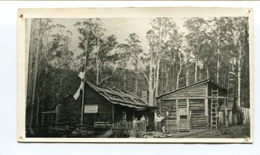 Orbost & District Historical Society
black and white photograph, late 19th century - early 20th century
Peter Jensen came to Martin's Creek (35 miles north of Orbost) in 1890 having been told that Martin's Creek would be on the railway line. He was a cooper who made the casks from silver wattles. He cleared the area for farming and then built an accommodation house, Danebo., which was well used by travellers to Bonang and Bendoc. . Gippsland was a relatively less developed part of Victoria in the nineteenth century. Danebo Hotel, Martin’s Creek, would have been an important stopping point for travellers to Bonang and Bendoc. The hotel is no longer standing A black / white photograph of a timber building - a house and another building at an angle. There are three people standing in front - a man. woman and child. On the left is a flag on a mast. In the background is bush.danebo-hotel-martins-creek jensen-peter -
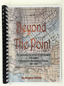 Warrnambool and District Historical Society Inc.
Booklet, Beyond the Point, 2007
This book was written in 2007 by Margaret McOrist to mark the 150th anniversary of the arrival in the Warrnambool area of John Logan. It is a sequel to a 1991 book, ‘Clotted Cream and Mangels’ which told the story of John Logan and his wife Mary Gardner. They lived at Hopkins Point, Warrnambool and the book, ‘Beyond the Point’ tells the story of the Logan descendants. When the farm land was sub-divided and sold the nearby beach was named ‘Logans Beach’. This book is of considerable interest as it tells the story of the descendants of important early settlers, John Logan and Mary Gardner. The area where they first settled is now of major interest as Logans Beach (named for the Logan family) is the well-known whale watching area. Southern Right Whales return to this beach each year and the females calve and remain up to three months at this beach, making it an important ‘whale nursery’. This is a soft cover book with black plastic ring binding and clear plastic sheets covering the front and back paper covers. The front cover has a reproduction of an 1891 map of Warrnambool and district with the title of the book and other information superimposed on the map. The back cover is black. The book has 101 pages and contains information on the Logan families who lived at Tooram in Allansford and their descendants. There are many black and white and colour photographs, diagrams, maps and family trees. Front Cover: ‘Beyond the Point, 150 years since the arrival of Irish ancestor, John Logan, Hopkins Point, Warrnambool, Victoria, 1857-2007, by Margaret McOrist’. john logan and mary gardner, hopkins point, logans beach, tooram, history of warrnambool -
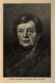 Ballarat and District Irish Association
Image, Daniel O'Connell, the Great Irish Agitator, c1864
Daniel O’Connell was born near Cahirciveen, Co. Kerry, on 6 August 1775. His wealthy childless uncle adopted him at an early age and brought him up at Derrynane. He spoke Irish and was interested in the traditional culture of song and story still strong in Kerry at the time. He also understood how the rural mind worked which served him well in later years. In 1791 he was sent to school at St. Omer and Douai and what he saw there of the French Revolution left him with a life-long hatred of violence. He read law at Lincoln’s Inn (1794 -96) and continued his studies in Dublin where he was called to bar in 1798. He had soon built up an enormous practice. The 1798 rising and the terrible butchery that followed it confirmed his horror of violence. While he approved of the principles of the United Irishmen, their call for reform and for Catholic Emancipation, he disagreed with their methods. In 1815 O’Connell criticised harshly the Dublin corporation. O’Connell was challenged to a duel by one member D’Esterre. In the exchange of shots D’Esterre was killed and O’Connell vowed never to fight again. O’Connell was soon drawn into political action. Hopes of Catholic emancipation had been raised by promises given while the act of union was being passed. In 1823, O’Connell founded the Catholic Association. The aim of the organisation was to use all the legal means available to secure emancipation. It turned into a mass crusade with the support of the Catholic clergy. All members of the association paid a membership of a penny a month (the Catholic rent). This helped to raise a large fund. The Clare election in 1828 was a turning point. O’Connell, with the support of the forty-shilling freeholders, managed a huge victory against the government candidate. He was well supported by the clergy whose influence on the poor uneducated peasant class was enormous. The polling took place in Ennis at the old courthouse where the O’Connell monument now stands. At the final count, O’Connell was elected by a majority of about eleven hundred votes. The ascendancy party had suffered its first big knock since 1798. The whole country was aflame. The British Government feared a rising and granted Catholic emancipation in April 1829. The franchise was, however, raised to 10 pounds which excluded the forty-shilling freeholders. O’Connell was now the undisputed leader in Ireland and he gave up his practice at the bar to devote his time entirely to politics. At the King’s insistence, O’Connell was not allowed to take his seat until he had been re-elected for Clare. In February 1830, O’Connell became the first Catholic in modern history to sit in the House of Commons. For the rest of his life, he was supported by “The O’Connell Tribute”, a public collection out of which O’Connell paid all his expenses. O’Connell now decided to concentrate on winning repeal of the act of union and getting an Irish parliament for the Irish people. British political leaders feared repeal as they did not fear emancipation. They saw repeal of the Act of Union as the first step in the break-up of the act of union, as the spirit of the repeal movement was revived when the young Ireland writers wrote about it in the Nation. In 1841, O’Connell was elected Lord Mayor of Dublin and in 1843 the subscriptions to his Repeal Association, the Repeal “Rent” came to 48,400 pounds. He now began to organise monster meetings throughout the country. It is thought that three-quarters of a million people gathered on the hill of Tara to hear the man they called the “Liberator”. The government became alarmed at the strength of the Repeal Movement and a meeting which O’Connell had planned for 8 October 1843 in Clontarf, Dublin was banned. Huge crowds were already on their way when O’Connell called off the meeting to avoid the risk of violence and bloodshed. He was charged with conspiracy, arrested and sentenced to a year in jail and a fine of 2,000 pounds. The sentence was set aside after O’Connell had been three months in prison. When he was released he continued with his campaign for repeal. However, a turning point had been reached. The tactics that had won emancipation had failed. O’Connell was now almost seventy, his health failing and he had no clear plan for future action. There was discontent within the Repeal Association and the Young Irelanders withdrew. There was also some failure in the potato crop in the 1840’s, a sign of things to come in the Great Famine of 1845-1847. Aware of the fact that he had failed with his great goal, (the Repeal Movement), O’Connell left Ireland for the last time in January 1847. He made a touching speech in the House of Commons in which he appealed for aid for his country. In March, acting on the advice of his doctor, he set out to Italy. Following his death in Genoa on 15 May 1847, his body was returned to Ireland and buried in Glasnevin Cemetery. [http://www.clarelibrary.ie/eolas/coclare/people/daniel.htm, accessed 13/12/2013]Portrait of a man known as Daniel O'Connell.ballarat irish, daniel o'connell, o'connell -
 Old Colonists' Association of Ballarat Inc.
Photograph - Photograph - Colour, Ballarat Old Colonists' Association Homes, Charles Anderson Grove, Ballarat
HISTORY OF THE BALLARAT OLD COLONISTS' ASSOCIATION HOMES AT CHARLES ANDERSON GROVE, LAKE GARDENS One of the original objectives of the Association was “to provide the shelter of a house for those Pioneers of the Goldfields whom the reverses of fortune have deprived of the means of procuring the comforts of life in their declining years.” While the first home at Charles Anderson Grove was built in 1925 the Association had previously provided relief for needy pioneers from the time it was formed in 1883. Relief included monthly monetary payments, loads of firewood, medical assistance and distribution of Christmas boxes of groceries to deserving pensioners and in some cases payment of burial costs. Records indicate that in September 1922 three of the pensioners being assisted by the Association were accepted as residents in the newly erected Hassell Homes in Gillies Street (now demolished-opposite the High School). The first site for an Asylum for Indigent Members of the Old Colonists' Association was temporarily reserved from sale in October 1891. The site was approximately 28 acres in area in Mt Clear nearly opposite Midvale Shopping Centre in Main Road. The site was heavily timbered and when cleared over 260 tons of wood was sold to the Woah Hawp Gold Mining Company. A set of gates were erected but no homes built, although a plan for this reserve was drawn which showed twenty buildings ranging from one to four unit per building. The reserve was revoked in November 1909. The second site temporarily reserved in November 1909 as an Asylum was in Alfredton and consisted of some 7 acres and was adjacent to land reserved for an Abattoirs for the Ballarat Council. The reserve was revoked in February 1912 as it was deemed more appropriate to be added to the Abattoir site. Council suggested four (4) other sites in exchange for this land and they were inspected by the President, Vice President and Secretary on 22 December 1912. The first site inspected was land on the west side of Creswick Road opposite the brick kilns (now occupied by the showgrounds and oval). The land was described as being good quality, well fenced, no trees, good drainage and ample acreage but some distance from trams. The second site was Perry Park which was described as being good land, well fenced, having frontage to Gillies Street, good drainage and about 26 acres (but subsequently reduced to 10 acres). It was closely planted with Pinus Insignias and Wattle and had easy access from the Botanic Gardens tram. The third site was the North West portion of Victoria Park (corner of Sturt and Gillies Street) and was described as good land, well fenced and drained and well located. The fourth site was the South West corner of Victoria Park and known as Pound Paddock (corner of Winter Street and Gillies Street). It was considered to be low lying and too close to the Abattoir, and was also a considerable distance from trams. While the third site was recommended as the most suitable for the erection of homes it was considered unwise from the point of view as citizens to reduce the acreage of the park and therefore it was recommended that the Perry Park site be asked for as the most acceptable to the Association for the building of homes. The site was eventually temporarily reserved for an Asylum for Indigent Members of the Association in April 1914 with the gates from Mt Clear having been removed to the site a year earlier and eventually erected in 1917 for £12.10.0. In the same year the first 290 pine trees were advertised for removal in July and sold for £16. A sign indicating that the site was reserved for the erection of cottages was erected in September 1917. Stripping of the wattle bark (for tanning) and the cutting of the wood occurred in November 1918 with the land then being leased until it was required for the construction of the first homes in 1924. While the site was the third to be reserved it was the only one which was used for its intended purpose. It was named as Charles Anderson Grove in honour of Charles Anderson who joined the Association in 1918 and was President of the Association from 1942 to 1944. A number of cottages in the Ballarat Old Colonists' Association Retirement Village of Gillies Street, Ballarat.charles anderson grove, old colonists' club, ballarat, old colonists' association, old colonists' homes, retirement village -
 Old Colonists' Association of Ballarat Inc.
Photograph - Image, The History of Charles Anderson and Charles Anderson Grove, Ballarat
Information relating to Charles Anderson and Charles Anderson Grove, Lake Gardens, Ballarat. The Old Colonists' Association Ballarat Inc. is a not for profit charitable organisation providing accommodation for elderly people. It manages a 27 Home retirement village at Charles Anderson Grove, Ballarat. Accommodation is offered at significantly below market rates. It has been providing low cost accommodation to the elderly since the 1920s. The Association Council overseas the running of this facility on a voluntary basis. HISTORY OF THE BALLARAT OLD COLONISTS' ASSOCIATION HOMES AT CHARLES ANDERSON GROVE, LAKE GARDENS One of the original objectives of the Association was “to provide the shelter of a house for those Pioneers of the Goldfields whom the reverses of fortune have deprived of the means of procuring the comforts of life in their declining years.” While the first home at Charles Anderson Grove was built in 1925 the Association had previously provided relief for needy pioneers from the time it was formed in 1883. Relief included monthly monetary payments, loads of firewood, medical assistance and distribution of Christmas boxes of groceries to deserving pensioners and in some cases payment of burial costs. Records indicate that in September 1922 three of the pensioners being assisted by the Association were accepted as residents in the newly erected Hassell Homes in Gillies Street (now demolished-opposite the High School). The first site for an Asylum for Indigent Members of the Old Colonists' Association was temporarily reserved from sale in October 1891. The site was approximately 28 acres in area in Mt Clear nearly opposite Midvale Shopping Centre in Main Road. The site was heavily timbered and when cleared over 260 tons of wood was sold to the Woah Hawp Gold Mining Company. A set of gates were erected but no homes built, although a plan for this reserve was drawn which showed twenty buildings ranging from one to four unit per building. The reserve was revoked in November 1909. The second site temporarily reserved in November 1909 as an Asylum was in Alfredton and consisted of some 7 acres and was adjacent to land reserved for an Abattoirs for the Ballarat Council. The reserve was revoked in February 1912 as it was deemed more appropriate to be added to the Abattoir site. Council suggested four (4) other sites in exchange for this land and they were inspected by the President, Vice President and Secretary on 22 December 1912. The first site inspected was land on the west side of Creswick Road opposite the brick kilns (now occupied by the showgrounds and oval). The land was described as being good quality, well fenced, no trees, good drainage and ample acreage but some distance from trams. The second site was Perry Park which was described as being good land, well fenced, having frontage to Gillies Street, good drainage and about 26 acres (but subsequently reduced to 10 acres). It was closely planted with Pinus Insignias and Wattle and had easy access from the Botanic Gardens tram. The third site was the North West portion of Victoria Park (corner of Sturt and Gillies Street) and was described as good land, well fenced and drained and well located. The fourth site was the South West corner of Victoria Park and known as Pound Paddock (corner of Winter Street and Gillies Street). It was considered to be low lying and too close to the Abattoir, and was also a considerable distance from trams. While the third site was recommended as the most suitable for the erection of homes it was considered unwise from the point of view as citizens to reduce the acreage of the park and therefore it was recommended that the Perry Park site be asked for as the most acceptable to the Association for the building of homes. The site was eventually temporarily reserved for an Asylum for Indigent Members of the Association in April 1914 with the gates from Mt Clear having been removed to the site a year earlier and eventually erected in 1917 for £12.10.0. In the same year the first 290 pine trees were advertised for removal in July and sold for £16. A sign indicating that the site was reserved for the erection of cottages was erected in September 1917. Stripping of the wattle bark (for tanning) and the cutting of the wood occurred in November 1918 with the land then being leased until it was required for the construction of the first homes in 1924. While the site was the third to be reserved it was the only one which was used for its intended purpose. It was named as Charles Anderson Grove in honour of Charles Anderson who joined the Association in 1918 and was President of the Association from 1942 to 1944. CHARLES HENRY GRATTAN ANDERSON C.H.G. Anderson (Electoral Returning Officer) was elected to membership of the Old Colonists' Association, Ballarat, in October 1918. He was elected to the Association Committee in 1926, and appointed Treasurer of the Association on the resignation of F. Ellis until the end of the financial year in 1933. In 1936 Charles Anderson indicated he would not be available for the President's Chair and that he would retire from the Committee owing to pressure of work. C.H.G. Anderson was welcomed as a new member of the Association in 1938, and served as President of the Old Colonists' Association from 1942-1944. Midway through 1949 Charles Anderson was appointed Members Secretary and Manager of the Ballarat Old Colonists' Club at £5.0.0 per week and 10/- for entertainment, to commence work prior to 01 August 1949. He was to do 30 hours per week and be present on Friday and generally on Saturday nights. In 1957 a minute of sympathy was extended to Club Manager Charles Anderson on the loss of his son. In 1958 a bonus of £20.0.0 was paid to Charles Anderson in recognition of his service in assisting the Secretary/Manager taking over under difficult conditions. In March 1964 the Shire of Ballarat would not permit a private road to be named Anderson Grove as Anderson Street already existed in Ballarat but Charles Anderson Grove was deemed acceptable. A recommendation of the Committee was put to the AGM in 1967 that Charles Anderson be made a Life Member. In 1969 an Association meeting observed a minutes silence in memory of Chas Anderson. Charles Anderson was also a Committee member of Ballarat Mechanics' Institute from February 1940 to February 1970. He was President in 1948. Black and white photographic portrait of Charles Anderson.charles anderson, charles anderson grove, ballarat old colonists' club, old colonists' association, ballarat, ballarat mechanics' institute, hassell homes, woah hawp gold mining company, firewood, retirement village -
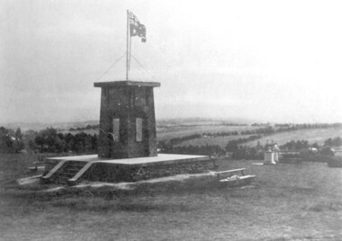 Surrey Hills Historical Society Collection
photograph, Ken Hall, Beckett Park Soldiers War Memorial c1932, c1980
Copy negative by Ken Hall from a c1933 City of Camberwell brochure. The original appears to have had a crease mark across it as this is evident on both copies.Black and white photo of the First World War memorial erected on the high point in Beckett Park, Balwyn. Taken with the memorial in the foreground and looking to the south-west. The Australian flag is flying on top of the monument and in the background are rows of trees dividing largely clear land.On the rear: Copy 1: "1153 Repeat of No 164" in top left hand corner in lead pencil in Jocelyn Hall's hand. Copy 2: "1153 Repeat of No 164" in top left hand corner in lead pencil in Jocelyn Hall's hand and "Soldiers War Memorial / Beckett Park / Erected 1918" in blue biro centre right.first world war, war memorial, beckett park -
 Kew Historical Society Inc
Plan - Subdivision Plan, Jas R Mathers Son & McMillan, The Dale Estate, Deepdene, 1918
Pru Sanderson, in her groundbreaking ‘City of Kew Urban Conservation Study : Volume 2 - Development History’ (1988), summarised the periods of urban development and subdivisions of land in Kew. The periods that she identified included 1845-1880, 1880-1893, 1893-1921, 1921-1933, 1933-1943, and Post-War Development. These periods were selected as they represented periods of rapid growth or decline in urban development. An obvious starting point for Sanderson’s groupings involved population growth and the associated economic cycles. These cycles also highlighted urban expansion onto land that was predominantly rural, although in other cases it represented the decline and breakup of large estates. A number of the plans in the Kew Historical Society’s collection can also be found in other collections, such as those of the State Library of Victoria and the Boroondara Library Service. A number are however unique to the collection.The Kew Historical Society collection includes almost 100 subdivision plans pertaining to suburbs of the City of Melbourne. Most of these are of Kew, Kew East or Studley Park, although a smaller number are plans of Camberwell, Deepdene, Balwyn and Hawthorn. It is believed that the majority of the plans were gifted to the Society by persons connected with the real estate firm - J. R. Mathers and McMillan, 136 Cotham Road, Kew. The Plans in the collection are rarely in pristine form, being working plans on which the agent would write notes and record lots sold and the prices of these. The subdivision plans are historically significant examples of the growth of urban Melbourne from the beginning of the 20th Century up until the 1980s. A number of the plans are double-sided and often include a photograph on the reverse. A number of the latter are by noted photographers such as J.E. Barnes.The Dale Estate in Deepdene was made possible by the death of Robert Sparrow Smythe, Australian journalist, newspaper editor/owner and theatrical manager. Smythe lived in his residence ‘Highate’, Deepdene until his death in 1917. In the subdivision proposed one year later, before the end of the First World War, 18 allotments were to be created. The very fragmentary plan in the Society’s collection notes that a large weatherboard [house] will need to be removed. This may be Smythe’s own home. The proposed subdivision included allotments facing Burke and Whitehorse Roads and Dale Street. Bordering the subdivision is the Deepdene Station and the Outer Circle Railway Line. The clear directions on the plan indicate that in 1918 it was possible to travel by train from Deepdene to East Camberwell and Ashburtonsubdivision plans - deepdene, the dale estate -
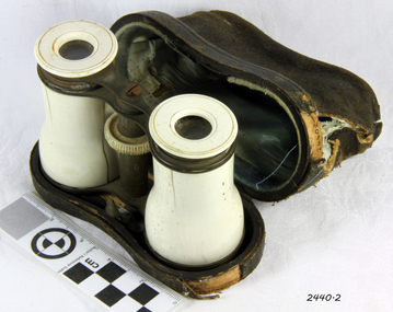 Flagstaff Hill Maritime Museum and Village
Opera Glasses & case, Early 20th Century
Opera Glasses came into existence as a result of a long line of inventions, and further improvements upon those inventions. The process started in the year 1608 when a Dutch optician by the name of Hans Lipperhey developed the first pair of binoculars with a magnification capability of X3. Less than a year later, a well-known inventor and philosopher by the name of Galileo developed what became known as the Galilean telescope. Advertisements were first found for opera glasses and theatre binoculars in London as early as 1730 in the form of a long collapsible telescope. The "Opera Glass" as it was referred to; was often covered in enamel, gems, ivory, or other art and paintings. For almost 100 years opera glasses existed merely as telescopes. In Vienna, in 1823 the first binocular opera glasses and theatre binoculars began to appear. They were two simple Galilean telescopes with a bridge in the centre, each telescope focused independently from the other by extending or shortening the telescope until the desired focus was achieved, which was useful, yet very cumbersome. Two years later in Paris, Pierre Lemiere improved on this design and created a centre focus wheel. This allowed the focusing of both telescopes together. After this development, opera glasses and theatre binoculars grew in popularity because of the superior view they facilitated in opera and theatre houses. The beautiful design of the glasses themselves also added appeal to the opera-going crowd. By the 1850's opera glasses and theatre, glasses had become a must-have fashion accessory for all opera and theatergoers.Not very significant as not associated with a historic event or person and made during the first half of the 20th Century and many are still available and easily sourced.Vintage Pair of Opera Glasses, with cow bone barrels and eyepieces, both barrel pieces have split in them, both metal end barrels each have a minor dent, optics are pretty clear no mould although have very minor dust spots inside, they look like they were gilded at some point but most of this has rubbed off glasses have a black leather case with blue lining. No markings whatsoever anywhereflagstaff hill, warrnambool, shipwrecked coast, flagstaff hill maritime museum, maritime museum, shipwreck coast, flagstaff hill maritime village, great ocean road, binoculars, opera glasses, theatre glasses, optical instrument, cow bone -
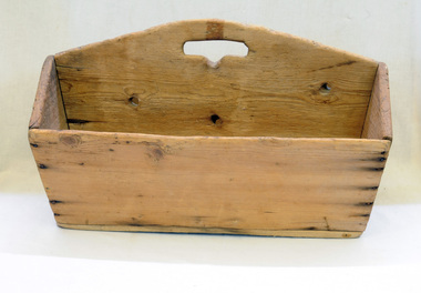 Orbost & District Historical Society
cutlery box, Jensen, Peter, Early 20th century
Made for Danebo Guest House at Martin's Creek. Peter Jensen came to Martin's Creek (35 miles north of Orbost) in 1890 having been told that Martin's Creek would be on the railway line. He was a cooper who made the casks from silver wattles. He cleared the area for farming and then built an accommodation house, Danebo., which was well used by travellers to Bonang and Bendoc. Gippsland was a relatively less developed part of Victoria in the nineteenth century. Danebo Hotel, Martin’s Creek, would have been an important stopping point for travellers to Bonang and Bendoc. The hotel is no longer standing.A open rectangular shaped wooden cutlery box - probably hand-made.. It has a carrying handle cut into the divider.jensen-peter martin's-creek danebo cutlery-box container -
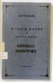 Orbost & District Historical Society
book, E-Gee Printers Pty Ltd, Butlers Wood's Point and Gippsland General Directory, 1985
This is a reprint of an original which was published in Melbourne by Butler & Brooke, Little Collins Street East. The original printer was W.H.Williams, 23 Little Bourke Street, Melbourne. On the spine was the title: Wood's Point and Gipps Land general directory, 1866.This is a copy of contemporary records of residents and businesses of Woods Point and Gippsland of 1866. It is a useful research tool.A soft covered 97pp book covered in clear plastic. The cover is blue with the title "Butlers Wood Point and Gippsland Directory" in black print with a black page border. It is a directory of residents, contemporary businesses (1866) and road guides. directory-gippsland-1866 butlers-directory -
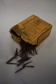 Warrnambool and District Historical Society Inc.
Household, Box of Tacks, Early 20th century
These tacks, made in U.S.A., would have been used in carpentry and small building processes and would most likely have been for household use. In many cases they have been replaced by clips and adhesive materials but are still used today. This box of tacks has no known local provenance and is kept for display purposes as an example of a household item from the past.This is a buff-coloured cardboard box containing metal tacks. The box is torn away at the top and has black printing on two sides. The box has been covered with clear cellophane to keep the contents safe. The tacks have a blunt head and taper to a point. They are rusted. ‘When you get a good thing remember where you got it’ ‘This trade mark is your protection. It guarantees the greatest quantity of quality at the price. Atlas Tack Corporation. Fairhaven Mass. St. Louis Mo.’ household items, history of warrnambool -
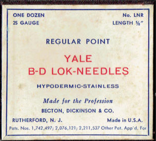 Geoffrey Kaye Museum of Anaesthetic History
Needles, Becton, Dickinson & Co
Brown and white cardboard box with white manufacturer's label adhered to the front. The box contains clear plastic tubes, holding two (2) metal needles in each tube. There is allocation for six (6) needles in the tubing, but only four (4) needles are present. There is allocation for another tubing section, but that is not present.Stamped into flat portion of connector: YALE / RUSTLESS / B-D / 25hypodermic, needle, syringe, yale, regular point, b-d lok, becton, dickinson & co, rutherford -
 B-24 Liberator Memorial Restoration Australia Inc
Oral History, Memories Of My Years in the RAAF and RAF 1942-1945 Ian Middleton, Circa 2000's
I.Middleton was in the RAAF from October 1942 until December 1945. He was a B-24 Liberator pilot between December 1944 and August 1945 with 70 SquadronThis oral history of Ian Middleton is of historical significance because it provides a first hand account of the individual's experience during World War II as a member of the RAAF who trained at Somers, Tasmania and Point Cook. He saw active service in the Mediterranean conflict flying B-24 Liberator aircraft from Italy.A4 paper printed transcript in bound plastic cover.Print of an RAAF flying wings badge. In printed silhouette clear roundel,Memories of My Years in the R.A.A.F. and R.A.F. 1942-1945 Underneath this a copy of a photo of a B-24 Liberator, Ian Middleton.oral history raaf world war ii -
 Coal Creek Community Park & Museum
Bottle, glass, c 1929-1950's ref: AGM mark on bottle base
TROVE : The Argus (Melbourne, Vic. : 1848 - 1957) Thursday 14 February 1867 p 1 Article 'THE EXHIBITION. OFFICIAL DISTRIBUTION OF PRIZES. The culminating point in the history of the Intercolonial Exhibition of 1866-7, was reached yesterday, when His Excellency Sir Henry Manners Sutton, Governor of Victoria, publicly received the reports of the jurors, and formally declared their awards. .........................CHEMICAL AND METALLURGICAL PRODUCTS AND PROCESSES....................... MEDALS - VIctoria .............John Kruse, chemist, Melbourne - For his fluid magnesia...........................'. Haines, Gregory, 1994, Á History of Pharmacy in Victoria, The Australian Pharmaceutical Publishing Company in association with the Pharmaceutical Society of Australai (Victoria) Ltd, Melbourne, Australia.opp. page 54, photo of 'John Kruse' and of 'John Kruse's pharmacy, Russell Street, Melbourne, 1866'. TROVE : Melbourne Punch (Vic. : 1855 - 1900) Thursday 21 January 1897 p 3 Article A Musical Genius. BY X. THERE is a chemist's shop in Hawthorn in the drawingroom over which some of the best, music that has ever been heard under the Southern Cross has been discoursed. Here John Kruse, the famous violinist , has delighted his late father with his violin. Here Nellie Mitchell's (Madame Melba's) voice found appreciative admiration long before she became famous. It is the shop of John Kruse, chemist and druggist, the inventor of fluid magnesia, insecticide and a world of well-known articles of daily consumption. The old mail died some time back, but lived long enough to gratify his chief wish, viz,, to see his famous son, Herr Johann Kruse. John journeyed from Germany to see his dying father. His brief but brilliant sojourn amongst us will be remembered by all lovers of music. TROVE: Colac Herald Friday 1 September 1876, page 4, Article. TROVE: The Argus Tuesday 2 July 1867, page 3, Advertisement. 'Felton Grimwade, 125 Russell Street, Melbourne'Clear glass bottle, oval shaped in section with text embossed on both sides and on base. Embossed on base 'M65' over '1923 6' over 'AGM'. Side 1 : 'KRUSES PRIZE MEDAL MAGNESIA' Side 2 : 'THIS BOTTLE IS THE PROPERTY OF FELTON GRIMWADE & CO PTY. LTD. MELBOURNE'. Over the numeral '1'.chemist, magnesia -
 Coal Creek Community Park & Museum
Bottle, glass, 1916-1923
Cylindrical clear glass bottle with text embossed on base'AGM' with point on 'A' -
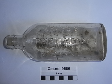
 Coal Creek Community Park & Museum
Bottle, glass, C. 1866 - 1895
TROVE : The Argus (Melbourne, Vic. : 1848 - 1957) Thursday 14 February 1867 p 1 Article 'THE EXHIBITION. OFFICIAL DISTRIBUTION OF PRIZES. The culminating point in the history of the Intercolonial Exhibition of 1866-7, was reached yesterday, when His Excellency Sir Henry Manners Sutton, Governor of Victoria, publicly received the reports of the jurors, and formally declared their awards. .........................CHEMICAL AND METALLURGICAL PRODUCTS AND PROCESSES....................... MEDALS - VIctoria .............John Kruse, chemist, Melbourne - For his fluid magnesia...........................'. Haines, Gregory, 1994, Á History of Pharmacy in Victoria, The Australian Pharmaceutical Publishing Company in association with the Pharmaceutical Society of Australai (Victoria) Ltd, Melbourne, Australia.opp. page 54, photo of 'John Kruse' and of 'John Kruse's pharmacy, Russell Street, Melbourne, 1866'. TROVE : Melbourne Punch (Vic. : 1855 - 1900) Thursday 21 January 1897 p 3 Article A Musical Genius. BY X. THERE is a chemist's shop in Hawthorn in the drawingroom over which some of the best, music that has ever been heard under the Southern Cross has been discoursed. Here John Kruse, the famous violinist , has delighted his late father with his violin. Here Nellie Mitchell's (Madame Melba's) voice found appreciative admiration long before she became famous. It is the shop of John Kruse, chemist and druggist, the inventor of fluid magnesia, insecticide and a world of well-known articles of daily consumption. The old mail died some time back, but lived long enough to gratify his chief wish, viz,, to see his famous son, Herr Johann Kruse. John journeyed from Germany to see his dying father. His brief but brilliant sojourn amongst us will be remembered by all lovers of music. TROVE: Colac Herald Friday 1 September 1876, page 4, Article. TROVE: The Argus Tuesday 2 July 1867, page 3, Advertisement. 'Felton Grimwade, 125 Russell Street, Melbourne' Clear glass ellipse in section bottle, with embossed text on both sides and initials and numerals on base.'KRUSES PRIZE MEDAL MAGNESIA', 'This bottle is the property of FELTON GRIMWADE & CO Pty Ltd Melbourne on sides. 'S1935' 'AGM' on base.magnesia, kruse, felton, grimwade, chemist -
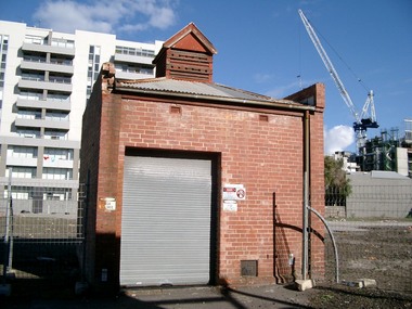 Port Melbourne Historical & Preservation Society
Photograph - Electrical sub-ststaion on block cleared for Muir development, Bay Street, Port Melbourne, Glen Stuart, Jun 2005
On land cleared for proposed "Muir" development not continued.at this point in 20052 colour photos of CitiPower sub-station left standing in block cleared for redevelopment on Bay Street.built environment - commercial, muir, sub-station -
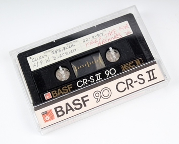 Melbourne Legacy
Audio - Recording, tape, Foundation Luncheon Speech 22/9/87, 22/9/1987
A recording of a speech made by Legatee P W Dietrich at the Foundation Day Luncheon in September 1987.A common method of audio recording at the time. The recording is compact, easily transported and easily mass produced.An audio tape cassette in a clear plastic container.Container, front BASF, 90 CR - S11 Side, Phil Dietrich Foundation Day Luncheon 22/9/87. Keep for archives. ( All written with red ball point pen). Tape cassette, side 1, Guest speaker L/PW Dietrich 22-9-87. (Written with black ball point pen). BASF CR - S11 90 IEC 11 Tape cassette, side 2, BASF, CR -11 90, IEC11.speech, legacy week -
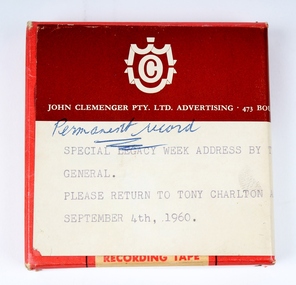 Melbourne Legacy
Audio - Recording, tape, Special Legacy Week Address by the Governor General, 1960
A special Legacy Week Address by the Governor General, in 1960. Legacy week was a time to appeal to the public for donations and the Governor of Victoria was the patron of Legacy.A record that the Governor General of Australia was involved in promoting Legacy during Legacy week in the 1960s.Cardboard box containing audio tape recording of the address by the Governor General in 1960.Cardboard box with paper sticker, John Clemenger Pty. Ltd. Adervertising. 473 Bourke Street, Melbourne. Permanent record wriiten with blue ball point pen. Special Legacy Week Address by the Governor General. Please return to Tony Charlton after use on September 4th, 1960. Cardboard box, recoding. Tape sato - 3 Clear plastic spool, audio tape plastic film.legacy week, legacy promotion, governor general -
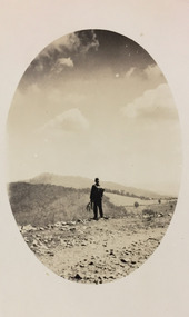 Kew Historical Society Inc
Photograph - Rural landscape, c.1926
Henry Beater Christian (1886-1962) , was a descendant of one of the earliest settler families in Kew. Employed at the Kew Asylum as a 'public servant', he was a skilled amateur photographer, photographing numerous scenes in Kew and on his travels around Victoria. The majority of his photographs date from 1916 to 1929. His finest photographs are housed in two photograph albums. Digital copy of a photograph from page 17 of the 47-page photograph album containing 261 gelatinous silver images, loaned by Diane Washfold with permission given to digitise and hold a copy in our collection. This photograph, dating from c.1926, forms part of a group of photos preceding images of [Black] Spur, so the photographs may have been taken as part of that bushwalking trip. John Chapman has written in 'Bushwalking Clubs - A Brief History', about the establishment in Victoria of the first bushwalking club in 1888, and the popularisation of bushwalking during the interwar period. Henry Christian's 'walks' appear to have been undertaken solely or with a companion/s. This camera shot invites the viewer to access the landscape through the point-of-view of the man standing with his back to the camera at the edge of the road. The man holds leaves in his left hand [to deter insects], and has a knapsack on his back. The landscape in the distance includes both cleared land for farming and remnant vegetation. The oval framing device was used when Henry Christian developed the photo.Illegible ink inscription on pagehenry beater christian (1886-1962), landscape photography, kew (vic.) — yarra river, christian-washfold collection, photograph albums, bushwalking -- victoria